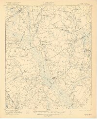
1921 Map of Mayesville
USGS Topo · Published 1921About this map
Black River Swamp dominates this landscape, its wide, braided drainage system separating the settlements of Mayesville and Scottsville in the north from the dense network of rural communities to the south. The agricultural economy of the early 1920s is marked by a high density of country churches and schools, such as Goodwill Church, St Peters Church, and Witherspoon School, reflecting a deeply settled rural society. Transportation relies on a combination of primary rail corridors like the Atlantic Coast Line and localized timber or agricultural lines including the Alcolu RR. The map captures specific points of local commerce at Wilsons Store and Friersons Store, while crossings such as Muldrows Crossing and McBride Crossing indicate the few reliable routes across the expansive swampy bottomlands.
Find a feature on this map
74 named features on this map. Tap any name to fly to it.
Don’t see what you’re looking for? This feature index may not catch every label — zoom into the map to look around manually.
Map Details
Editions of this 1921 Mayesville Map
3 editions found
Other maps of this area

1920 · Mayesville
USGS Topo · 1:48,000

1920 · Manning
USGS Topo · 1:48,000

1921 · Manning
USGS Topo · 1:62,500

1921 · Mayesville
USGS Topo · 1:62,500

1940 · Florence West
USGS Topo · 1:62,500

1941 · Spartanburg
USGS Topo · 1:250,000

1943 · Mayesville
USGS Topo · 1:62,500

1944 · Manning
USGS Topo · 1:62,500

1945 · Florence West
USGS Topo · 1:62,500

1946 · Kingstree
USGS Topo · 1:62,500