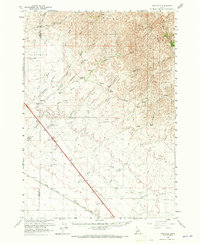
1960 Map of Mayfield
USGS Topo · Published 1972About this map
Mayfield serves as the focal point for this 1960s landscape, situated where the high desert meets the foothills of the Boise National Forest. The settlement pattern is defined by remote agricultural outposts such as Seven L Ranch, Thomson Ranch, and Bennett Ranch, which rely on a network of intermittent water sources like Indian Creek and Roast Creek. The Union Pacific (Oregon Short Line) railroad cuts a diagonal path through the southwestern portion of the map, supporting the siding at Regina and marking the era's primary transportation corridor.
Find a feature on this map
66 named features on this map. Tap any name to fly to it.
Don’t see what you’re looking for? This feature index may not catch every label — zoom into the map to look around manually.
Map Details
Editions of this 1960 Mayfield Map
3 editions found

Other maps of this area

1892 · Mountain Home
USGS Topo · 1:125,000

1892 · Boise
USGS Topo · 1:125,000

1892 · Bisuka
USGS Topo · 1:125,000

1893 · Mountain Home
USGS Topo · 1:125,000

1894 · Bisuka
USGS Topo · 1:125,000

1894 · Idaho Basin
USGS Topo · 1:125,000

1897 · Boise
USGS Topo · 1:125,000

1948 · Big Foot Butte
USGS Topo · 1:62,500

1948 · Little Joe Butte
USGS Topo · 1:24,000

1949 · Little Joe Butte
USGS Topo · 1:24,000