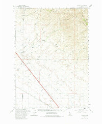
1960 Map of Mayfield
USGS Topo · Published 1983About this map
Mayfield stands at the center of this high-desert landscape during the early 1960s, serving as a focal point for the surrounding ranching country. The map illustrates a rural economy defined by livestock and transit, featuring the Seven L Ranch, Thomson Ranch, and Bennett Ranch scattered across the drainage basins of Indian Creek and McIntyre Creek. To the south, the transportation corridor is clearly marked by the parallel tracks of the Union Pacific and Oregon Short Line railroads, crossing the boundary between Ada and Elmore counties. The northern portion of the quadrangle transitions into the steep slopes of the Boise National Forest, where labels like The Roost and Porcupine Creek indicate the varied terrain. This survey provides a record of the early infrastructure in the region, including a prominent pipeline and the historic Base Line Road stretching across the flats.
Find a feature on this map
49 named features on this map. Tap any name to fly to it.
Don’t see what you’re looking for? This feature index may not catch every label — zoom into the map to look around manually.
Map Details
Editions of this 1960 Mayfield Map
3 editions found

Other maps of this area

1892 · Mountain Home
USGS Topo · 1:125,000

1892 · Boise
USGS Topo · 1:125,000

1892 · Bisuka
USGS Topo · 1:125,000

1893 · Mountain Home
USGS Topo · 1:125,000

1894 · Bisuka
USGS Topo · 1:125,000

1894 · Idaho Basin
USGS Topo · 1:125,000

1897 · Boise
USGS Topo · 1:125,000

1948 · Big Foot Butte
USGS Topo · 1:62,500

1948 · Little Joe Butte
USGS Topo · 1:24,000

1949 · Little Joe Butte
USGS Topo · 1:24,000