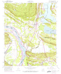
1953 Map of Mayflower
USGS Topo · Published 1970About this map
The Arkansas River serves as the dominant geographical divide on this sheet, separating the upland ridges of Pine Mountain and Reynolds Mountain from the riparian lowlands of Beaverdam Island. The town of Mayflower is positioned near the shores of Cadron Lake and Clear Lake, where a dense network of local landings such as Paradise Landing and Sport Haven Landing illustrates the area's mid-century water-based recreation and settlement pattern.
Find a feature on this map
46 named features on this map. Tap any name to fly to it.
Don’t see what you’re looking for? This feature index may not catch every label — zoom into the map to look around manually.
Map Details
Editions of this 1953 Mayflower Map
5 editions found
Other maps of this area

1890 · Benton
USGS Topo · 1:125,000

1891 · Little Rock
USGS Topo · 1:125,000

1892 · Morrillton
USGS Topo · 1:125,000

1893 · Little Rock
USGS Topo · 1:125,000

1894 · Morrillton
USGS Topo · 1:125,000

1894 · Benton
USGS Topo · 1:125,000

1935 · North Little Rock
USGS Topo · 1:24,000

1943 · Pinnacle Mtn
USGS Topo · 1:31,680

1953 · Cato
USGS Topo · 1:24,000

1953 · Mayflower
USGS Topo · 1:24,000