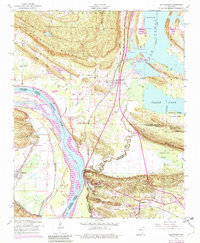
1953 Map of Mayflower
USGS Topo · Published 1982About this map
Arkansas River navigation and the rugged ridges of the Ouachita foothills define this landscape along the boundary of Faulkner and Pulaski counties. The settlement of Mayflower is positioned near the shores of Clear Lake, where a dense network of docks including Jacks Landing, Paradise Landing, and Pooles Landing indicates the area's importance for river and lake access. To the south, the terrain rises sharply into Piney Mountain and Reynolds Mountain, while the lowlands are marked by significant sites like the National Guard Training Area and the grounds of Former Camp Joseph T Robinson. Small rural communities and church congregations are well-preserved in this record, from White City Church near the river to Mount Pilgrim Church and Trinity Grove Church further inland. The Missouri Pacific and Chicago Rock Island and Pacific railroads trace the natural corridors through the hills and valleys.
Find a feature on this map
40 named features on this map. Tap any name to fly to it.
Don’t see what you’re looking for? This feature index may not catch every label — zoom into the map to look around manually.
Map Details
Editions of this 1953 Mayflower Map
5 editions found
Other maps of this area

1890 · Benton
USGS Topo · 1:125,000

1891 · Little Rock
USGS Topo · 1:125,000

1892 · Morrillton
USGS Topo · 1:125,000

1893 · Little Rock
USGS Topo · 1:125,000

1894 · Morrillton
USGS Topo · 1:125,000

1894 · Benton
USGS Topo · 1:125,000

1935 · North Little Rock
USGS Topo · 1:24,000

1943 · Pinnacle Mtn
USGS Topo · 1:31,680

1953 · Cato
USGS Topo · 1:24,000

1953 · Mayflower
USGS Topo · 1:24,000