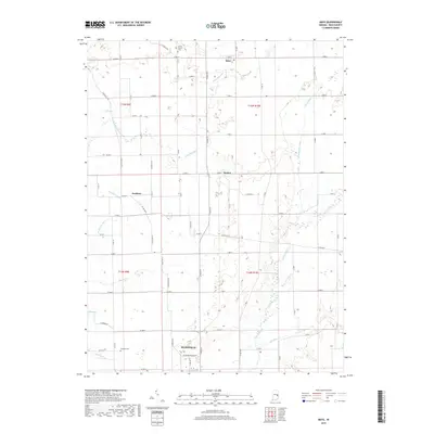
2019 Map of Mays
USGS Topo · Published 2019About this map
The Flatrock River and Little Blue River define this rural landscape in northern Rush County, where agricultural patterns are etched into the terrain by a complex network of drainage systems like Newhouse Ditch and Henderson Ditch. The northern edge of Rushville anchors the south, while smaller rural nodes such as Mays, Sexton, and Occident are scattered along a grid of county roads. These intersections often preserve the early markers of the community, including Center Church and its accompanying Cemetery near the northern boundary.
Find a feature on this map
77 named features on this map. Tap any name to fly to it.
Don’t see what you’re looking for? This feature index may not catch every label — zoom into the map to look around manually.
Map Details
Editions of this 2019 Mays Map
This is the sole edition of this map. No revisions or reprints were ever made.
Other maps of this area

1948 · Lewisville
USGS Topo · 1:24,000

1950 · Dunreith
USGS Topo · 1:24,000

1950 · Lewisville
USGS Topo · 1:24,000

1953 · Cincinnati
USGS Topo · 1:250,000

1957 · Cincinnati
USGS Topo · 1:250,000

1959 · Rushville
USGS Topo · 1:24,000

1959 · New Salem
USGS Topo · 1:24,000

1959 · Mays
USGS Topo · 1:24,000

1959 · Falmouth
USGS Topo · 1:24,000
1960 · Manilla
USGS Topo · 1:24,000