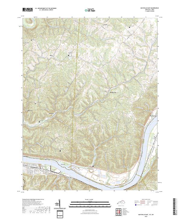
2022 Map of Maysville East
USGS Topo · Published 2022About this map
The Ohio River carves a sweeping arc through this borderlands landscape, separating Maysville and Aberdeen while defining the rugged terrain of northern Kentucky and southern Ohio. The map captures a complex network of ridges and hollows, where family history is preserved in small upland burial grounds like Hiett Chapel Cem and Ebenezer Churchyard Cem. Small settlements such as Slickaway, Ellsberry, and Bradysville anchor the rural road system, connected by historic routes like Clayton Pike and Old State Rd. Along the riverbank, hydrological features like Brooks Bar and The Sand Fills reflect the shifting depositional nature of the waterway. Land use is dictated by the steep topography of Blooming Ridge and Ginger Ridge, where creek beds like Big Threemile Cr and Eagle Creek have historically guided movement through the valleys.
Find a feature on this map
104 named features on this map. Tap any name to fly to it.
Don’t see what you’re looking for? This feature index may not catch every label — zoom into the map to look around manually.
Map Details
Editions of this 2022 Maysville East Map
This is the sole edition of this map. No revisions or reprints were ever made.
Other maps of this area

1915 · Maysville
USGS Topo · 1:62,500

1918 · Seaman
USGS Topo · 1:62,500

1919 · Maysville
USGS Topo · 1:62,500

1928 · Higginsport
USGS Topo · 1:48,000

1929 · Springdale
USGS Topo · 1:48,000

1931 · Higginsport
USGS Topo · 1:62,500

1935 · Springdale
USGS Topo · 1:62,500

1952 · Maysville East
USGS Topo · 1:24,000

1952 · Maysville West
USGS Topo · 1:24,000
1952 · Orangeburg
USGS Topo · 1:24,000