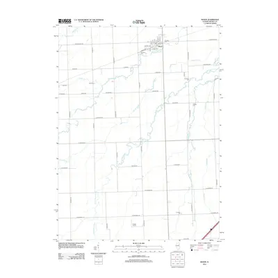
2012 Map of Mazon
USGS Topo · Published 2012About this map
The village of Mazon serves as the central hub for this portion of Grundy County, organized around a compact grid of streets including Front St, Depot St, and Harmony Ave. The surrounding landscape is defined by the wandering path of the W Fork Mazon River and its various tributaries such as Johnny Run, Gooseberry Cr, and Murray Slough. This prairie region shows a high density of small family and community burial grounds, preserving local lineages at Brookside Cem, Old Mazon Cem, Ward Cem, and Wheeler Cem. The road network follows a strict rectilinear section-line grid, typical of Illinois farm country, punctuated by aviation infrastructure at the Dwight Airport in the southern portion of the quadrangle. Smaller watercourses like Thunder Cr and Woods Run cut through the agricultural fields, illustrating the natural drainage patterns that have shaped the local economy and settlement for generations.
Find a feature on this map
56 named features on this map. Tap any name to fly to it.
Don’t see what you’re looking for? This feature index may not catch every label — zoom into the map to look around manually.
Map Details
Editions of this 2012 Mazon Map
This is the sole edition of this map. No revisions or reprints were ever made.
Other maps of this area

1892 · Morris
USGS Topo · 1:62,500

1892 · Marseilles
USGS Topo · 1:62,500

1916 · Marseilles
USGS Topo · 1:62,500

1918 · Morris
USGS Topo · 1:62,500

1940 · Marseilles
USGS Topo · 1:62,500

1948 · Dwight
USGS Topo · 1:62,500

1950 · Dwight
USGS Topo · 1:62,500

1953 · Morris
USGS Topo · 1:24,000

1953 · Coal City
USGS Topo · 1:24,000
1954 · Morris
USGS Topo · 1:62,500