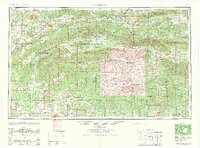
1965 Map of Mc Alester
USGS Topo · Published 1965About this map
The Choctaw Nation’s complex topography defines this mid-century portrait of southeastern Oklahoma and western Arkansas. Stretching from the coal-rich vicinity of McAlester east toward the Arkansas border, the landscape is dominated by the linear ridges of the Ouachita Mountains, including Winding Stair Mountain and the Kiamichi Mountains. The map documents a critical period for water management and transit, showing the expansive reach of Eufaula Lake and the intricate drainage of the Kiamichi River and Poteau River.
Find a feature on this map
91 named features on this map. Tap any name to fly to it.
Don’t see what you’re looking for? This feature index may not catch every label — zoom into the map to look around manually.
Map Details
Editions of this 1965 Mc Alester Map
3 editions found

Other maps of this area

1879 · Poteau Mountain
USGS Topo · 1:62,500

1887 · Poteau Mountain #1
USGS Topo · 1:62,500

1887 · Mount Ida #2
USGS Topo · 1:62,500

1887 · Magazine Mountain #3
USGS Topo · 1:62,500

1887 · Magazine Mountain
USGS Topo · 1:62,500

1887 · Poteau Mountain #2
USGS Topo · 1:62,500

1887 · Greenwood
USGS Topo · 1:62,500

1890 · Magazine Mountain
USGS Topo · 1:125,000

1890 · Mount Ida
USGS Topo · 1:125,000

1890 · Fort Smith
USGS Topo · 1:125,000