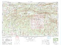
1965 Map of Mc Alester
USGS Topo · Published 1965About this map
The ridge-and-valley landscape of the Ouachita Mountains dominates this mid-century survey, revealing a region defined by its timbered slopes and coal-mining heritage. Industrial corridors are anchored by the Chicago Rock Island and Pacific RR, which connects the major centers of McAlester, Hartshorne, and Wilburton along the northern edge of the mountain front. Small mining and rail towns like Carbon, Adamson, and Lutie populate this corridor, while the Kansas City Southern RR drives north-south through Heavener and Hodgen.
Find a feature on this map
173 named features on this map. Tap any name to fly to it.
Don’t see what you’re looking for? This feature index may not catch every label — zoom into the map to look around manually.
Map Details
Editions of this 1965 Mc Alester Map
3 editions found

Other maps of this area

1879 · Poteau Mountain
USGS Topo · 1:62,500

1887 · Poteau Mountain #1
USGS Topo · 1:62,500

1887 · Mount Ida #2
USGS Topo · 1:62,500

1887 · Magazine Mountain #3
USGS Topo · 1:62,500

1887 · Magazine Mountain
USGS Topo · 1:62,500

1887 · Poteau Mountain #2
USGS Topo · 1:62,500

1887 · Greenwood
USGS Topo · 1:62,500

1890 · Magazine Mountain
USGS Topo · 1:125,000

1890 · Mount Ida
USGS Topo · 1:125,000

1890 · Fort Smith
USGS Topo · 1:125,000