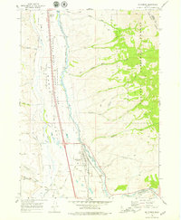
1968 Map of Mc Cammon
USGS Topo · Published 1979About this map
The McCammon townsite serves as the central hub of this late-1960s Idaho landscape, situated where the Union Pacific railroad lines converge along the Portneuf River. This area in Bannock County is a complex intersection of ancient history and modern infrastructure, featuring the Petroglyphs Rest Area near Indian Rocks. The geography is defined by the transition from the wide Marsh Valley to the rising elevations of the Caribou Range, which is protected as part of the Caribou National Forest. Evidence of historical land management and transit is visible through the Old Indian Treaty Bdy and the Marsh Valley Canal. Numerous canyons, including Mullen Canyon and Dry Canyon, cut through the eastern highlands, while local industry is noted through several Gravel Pits and a Borrow Pit scattered throughout the valley floor.
Find a feature on this map
44 named features on this map. Tap any name to fly to it.
Don’t see what you’re looking for? This feature index may not catch every label — zoom into the map to look around manually.
Map Details
Editions of this 1968 Mc Cammon Map
2 editions found

Other maps of this area

1937 · Pocatello
USGS Topo · 1:48,000

1944 · Pocatello
USGS Topo · 1:62,500

1954 · Pocatello
USGS Topo · 1:250,000

1958 · Pocatello
USGS Topo · 1:250,000

1968 · Bear Camp Gulch
USGS Topo · 1:24,000

1968 · Hawkins
USGS Topo · 1:24,000

1968 · Lava Hot Springs
USGS Topo · 1:24,000
1968 · Arimo
USGS Topo · 1:24,000
1968 · Bonneville Peak
USGS Topo · 1:24,000
1968 · Haystack Mtn
USGS Topo · 1:24,000