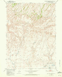
1951 Map of Mc Cleary Reservoir
USGS Topo · Published 1972About this map
The Rattlesnake Hills dominate the northern landscape of this Natrona County region, giving way to a series of drainage systems and draws that define the local topography. In the early 1950s, this area supported modest ranching operations, centered around locations like the UC Ranch and CRI Ranch. The presence of the CRI School suggests a small but established rural community during this period, serving families situated along the water sources of Henderson Creek and Shell Creek.
Find a feature on this map
15 named features on this map. Tap any name to fly to it.
Don’t see what you’re looking for? This feature index may not catch every label — zoom into the map to look around manually.
Map Details
Editions of this 1951 Mc Cleary Reservoir Map
4 editions found
Other maps of this area

1951 · Pine Mountain SW
USGS Topo · 1:24,000

1951 · Benton Basin SW
USGS Topo · 1:24,000

1951 · Benton Basin
USGS Topo · 1:24,000

1951 · Poison Spider
USGS Topo · 1:24,000

1951 · Benton Basin NE
USGS Topo · 1:24,000

1951 · Mc Cleary Reservoir
USGS Topo · 1:24,000

1955 · Casper
USGS Topo · 1:250,000

1958 · Casper
USGS Topo · 1:250,000

1959 · Eightmile Draw
USGS Topo · 1:24,000

1959 · Horse Creek Springs
USGS Topo · 1:24,000