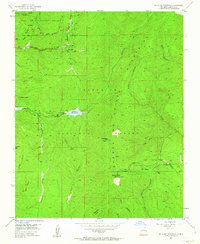
1953 Map of Mc Clure Reservoir
USGS Topo · Published 1963About this map
The Juan De Gabaldon Grant and Santiago Ramirez Grant define much of the land tenure in this mountainous section of the Santa Fe National Forest during the mid-twentieth century. High-altitude water management is central to the landscape, anchored by the Mc Clure Reservoir and Nichols Res along the Santa Fe River. These reservoirs, along with Aztec Springs and the headwaters of Arroyo Hondo, reflect the critical infrastructure required to support the regional population. Local recreation and fire overwatch are evidenced by the Evergreen Lodge, the Black Canyon Forest Camp, and the Glorieta Baldy VABM 10199 Lookout Station perched at over ten thousand feet. A network of historic paths, including the Windsor Trail and Chamiza Trail, cuts through the steep canyons such as Macho Canyon and Apache Canyon.
Find a feature on this map
39 named features on this map. Tap any name to fly to it.
Don’t see what you’re looking for? This feature index may not catch every label — zoom into the map to look around manually.
Map Details
Editions of this 1953 Mc Clure Reservoir Map
5 editions found
Other maps of this area

1889 · Santa Fe
USGS Topo · 1:125,000

1894 · Santa Fe
USGS Topo · 1:125,000

1952 · Santa Fe
USGS Topo · 1:24,000

1952 · Seton Village
USGS Topo · 1:24,000

1953 · Tesuque
USGS Topo · 1:24,000

1953 · Glorieta
USGS Topo · 1:24,000

1953 · Mc Clure Reservoir
USGS Topo · 1:24,000

1953 · Aspen Basin
USGS Topo · 1:24,000

1954 · Santa Fe
USGS Topo · 1:250,000

1958 · Santa Fe
USGS Topo · 1:250,000