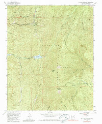
1953 Map of Mc Clure Reservoir
USGS Topo · Published 1980About this map
The high peaks and deep canyons of the Santa Fe Mountains dominate this 1953 landscape, centered on critical water resources for the state capital. The Santa Fe River serves as the primary drainage, feeding into Mc Clure Reservoir and Nichols Res, which are flanked by the Santiago Ramirez Grant. Higher elevations are defined by prominent landmarks like Thompson Peak and Atalaya Mtn, while the Glorieta Baldy VABM 10199 Lookout Station stands as a sentinel over the southern ridge lines.
Find a feature on this map
36 named features on this map. Tap any name to fly to it.
Don’t see what you’re looking for? This feature index may not catch every label — zoom into the map to look around manually.
Map Details
Editions of this 1953 Mc Clure Reservoir Map
5 editions found
Other maps of this area

1889 · Santa Fe
USGS Topo · 1:125,000

1894 · Santa Fe
USGS Topo · 1:125,000

1952 · Santa Fe
USGS Topo · 1:24,000

1952 · Seton Village
USGS Topo · 1:24,000

1953 · Tesuque
USGS Topo · 1:24,000

1953 · Glorieta
USGS Topo · 1:24,000

1953 · Mc Clure Reservoir
USGS Topo · 1:24,000

1953 · Aspen Basin
USGS Topo · 1:24,000

1954 · Santa Fe
USGS Topo · 1:250,000

1958 · Santa Fe
USGS Topo · 1:250,000