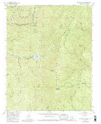
1953 Map of Mc Clure Reservoir
USGS Topo · Published 1980About this map
Mc Clure Reservoir and Nichols Res dominate the central topography of this mid-century survey, serving as critical water infrastructure along the Santa Fe River. The landscape is defined by the high elevations of the Sangre de Cristo Mountains, where the Glorieta Baldy Lookout Station stands at over ten thousand feet. Large land tracts, including the Juan de Gabaldon Grant and the Santiago Ramirez Grant, reflect the enduring legacy of Spanish land grants within the Santa Fe National Forest. Recreational and historical markers such as Evergreen Lodge and the Windsor Trail indicate the area's development for outdoor access, while the numerous canyons like Dalton Canyon and La Cueva Canyon illustrate the complex drainage patterns feeding the river system south of Tesuque Creek.
Find a feature on this map
31 named features on this map. Tap any name to fly to it.
Don’t see what you’re looking for? This feature index may not catch every label — zoom into the map to look around manually.
Map Details
Editions of this 1953 Mc Clure Reservoir Map
5 editions found
Other maps of this area

1889 · Santa Fe
USGS Topo · 1:125,000

1894 · Santa Fe
USGS Topo · 1:125,000

1952 · Santa Fe
USGS Topo · 1:24,000

1952 · Seton Village
USGS Topo · 1:24,000

1953 · Tesuque
USGS Topo · 1:24,000

1953 · Glorieta
USGS Topo · 1:24,000

1953 · Mc Clure Reservoir
USGS Topo · 1:24,000

1953 · Aspen Basin
USGS Topo · 1:24,000

1954 · Santa Fe
USGS Topo · 1:250,000

1958 · Santa Fe
USGS Topo · 1:250,000