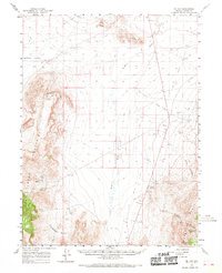
1961 Map of Mc Coy
USGS Topo · Published 1970About this map
The high-desert terrain of central Nevada is defined here by the meeting of the Fish Creek Mountains and the Shoshone Range. This 1961 survey documents a landscape focused on mineral extraction and livestock water sources, with the McCoy Mine and Mountain Springs Mine situated in the southwestern and southeastern uplands respectively. The valley floor is marked by the Reese River and several essential water points such as Natomas Well, Pickett Well, and Dillon Well, which were vital for ranching and mining operations in this arid environment.
Find a feature on this map
25 named features on this map. Tap any name to fly to it.
Don’t see what you’re looking for? This feature index may not catch every label — zoom into the map to look around manually.
Map Details
Editions of this 1961 Mc Coy Map
3 editions found
Other maps of this area

1932 · Sonoma Range
USGS Topo · 1:250,000

1939 · Sonoma Range
USGS Topo · 1:250,000

1940 · Antler Peak
USGS Topo · 1:62,500

1943 · Antler Peak
USGS Topo · 1:62,500

1949 · Mt. Lewis
USGS Topo · 1:62,500

1950 · Mt. Lewis
USGS Topo · 1:62,500

1955 · Winnemucca
USGS Topo · 1:250,000

1957 · Battle Mountain
USGS Topo · 1:62,500

1958 · Winnemucca
USGS Topo · 1:250,000

1961 · McCoy
USGS Topo · 1:62,500