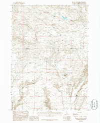
1986 Map of Mc Han Reservoir
USGS Topo · Published 1986About this map
Mc Han Reservoir sits at the center of this high-desert landscape in south-central Idaho, where the border between Camas and Gooding Counties cuts through the high plateau. The terrain is defined by a network of drainage systems including Black Canyon, Willow Canyon, and Burnt Canyon, which shape the approach to the distinctive geological formations of the Little City of Rocks in the south. This 1980s-era survey documents a land primarily used for grazing and resource extraction, evidenced by scattered Gravel Pits and a Quarry near Johnson Hill.
Find a feature on this map
23 named features on this map. Tap any name to fly to it.
Don’t see what you’re looking for? This feature index may not catch every label — zoom into the map to look around manually.
Map Details
Editions of this 1986 Mc Han Reservoir Map
This is the sole edition of this map. No revisions or reprints were ever made.
Other maps of this area

1955 · Hailey
USGS Topo · 1:250,000

1957 · Fairfield
USGS Topo · 1:62,500

1957 · Thorn Creek SE
USGS Topo · 1:24,000

1957 · Thorn Creek SW
USGS Topo · 1:24,000

1957 · Thorn Creek
USGS Topo · 1:62,500

1957 · Davis Mountain
USGS Topo · 1:62,500

1957 · Blaine
USGS Topo · 1:62,500

1959 · Hailey
USGS Topo · 1:250,000

1962 · Hailey
USGS Topo · 1:250,000
1986 · Thorn Creek Reservoir
USGS Topo · 1:24,000