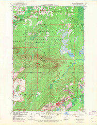
1950 Map of Mc Kinley
USGS Topo · Published 1971About this map
The Laurentian Divide carves across this landscape, marking the geological crest where waters split their journey toward either the Arctic or the Atlantic. This survey captures the Iron Range at a pivotal mid-century moment, showing the heavy industrial footprint of the Duluth Missabe and Iron Range railroad serving the mining operations around McKinley and Biwabik. The map reveals the juxtaposition of the extraction industry and the wilderness, with the southern boundary of the Superior National Forest and the peaks of Pike Mountain and Missabe Mountain rising near expansive mine dumps. Local settlements like Belgrade, Franklin, and Florenton are clearly delineated, along with smaller community markers such as the Florenton Cem and the Town Hall, providing essential details for those tracing the human and industrial history of this northern Minnesota mining corridor.
Find a feature on this map
26 named features on this map. Tap any name to fly to it.
Don’t see what you’re looking for? This feature index may not catch every label — zoom into the map to look around manually.
Map Details
Editions of this 1950 Mc Kinley Map
4 editions found
Other maps of this area

1950 · Biwabik
USGS Topo · 1:24,000

1950 · Mc Kinley
USGS Topo · 1:24,000

1950 · Biwabik NW
USGS Topo · 1:24,000

1950 · Biwabik NE
USGS Topo · 1:24,000

1951 · Biwabik
USGS Topo · 1:24,000

1951 · Mc Kinley
USGS Topo · 1:24,000

1951 · Biwabik NE
USGS Topo · 1:24,000

1951 · Biwabik NW
USGS Topo · 1:24,000

1951 · Palo
USGS Topo · 1:24,000

1951 · Gilbert
USGS Topo · 1:24,000