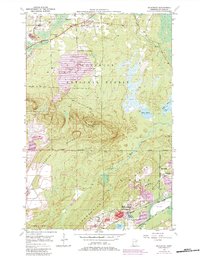
1950 Map of Mc Kinley
USGS Topo · Published 1983About this map
Laurentian Divide cuts across this section of the Mesabi Range, marking the geographic boundary between waters flowing toward the Arctic and those heading to the Atlantic. The landscape is defined by the industrial footprint of the mid-20th century, with significant earthwork identified as Mine Dump and Tailings Pond sites surrounding the settlements of Elcor, McKinley, and Biwabik. The proximity of the Duluth Missabe and Iron Range railroad to the Corsica Mine illustrates the intense resource extraction that drove the local economy during this era. North of the heavy mining activity, the Superior National Forest provides a sharp contrast, where the Pike River winds toward Hay Lake and the high point of Pike Mountain is marked by a Lookout Tower. Smaller community details like the Florentine Cem and the Town Hall near the northern boundary offer specific points of interest for genealogists tracing family roots in these mining towns.
Find a feature on this map
23 named features on this map. Tap any name to fly to it.
Don’t see what you’re looking for? This feature index may not catch every label — zoom into the map to look around manually.
Map Details
Editions of this 1950 Mc Kinley Map
4 editions found
Other maps of this area

1950 · Biwabik
USGS Topo · 1:24,000

1950 · Mc Kinley
USGS Topo · 1:24,000

1950 · Biwabik NW
USGS Topo · 1:24,000

1950 · Biwabik NE
USGS Topo · 1:24,000

1951 · Biwabik
USGS Topo · 1:24,000

1951 · Mc Kinley
USGS Topo · 1:24,000

1951 · Biwabik NE
USGS Topo · 1:24,000

1951 · Biwabik NW
USGS Topo · 1:24,000

1951 · Palo
USGS Topo · 1:24,000

1951 · Gilbert
USGS Topo · 1:24,000