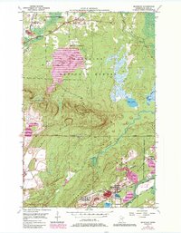
1950 Map of Mc Kinley
USGS Topo · Published 1985About this map
Laurentian Divide cuts through this portion of the Mesabi Range, where industrial activity and the Superior National Forest meet. The map reveals the intense mining footprint of the mid-20th century, with numerous Mine Dumps and pits surrounding the settlements of Elcor, McKinley, and Belgrade. These communities are inextricably linked to the extraction economy, served by the Duluth Missabe and Iron Range railroad that snakes through the valley. Away from the heavy industry of the south, the landscape transitions into the wooded terrain of Pike Mountain, where a Lookout Tower and the local Town Hall anchor the rural community. Water features like the Pike River and Hay Lake provide a natural contrast to the industrial excavations, while the Florenton Cem offers a point of interest for those researching local family history and the early inhabitants of these mining towns.
Find a feature on this map
21 named features on this map. Tap any name to fly to it.
Don’t see what you’re looking for? This feature index may not catch every label — zoom into the map to look around manually.
Map Details
Editions of this 1950 Mc Kinley Map
4 editions found
Other maps of this area

1950 · Biwabik
USGS Topo · 1:24,000

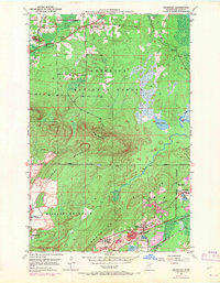
1950 · Mc Kinley
USGS Topo · 1:24,000

1950 · Biwabik NW
USGS Topo · 1:24,000

1950 · Biwabik NE
USGS Topo · 1:24,000

1951 · Biwabik
USGS Topo · 1:24,000

1951 · Mc Kinley
USGS Topo · 1:24,000

1951 · Biwabik NE
USGS Topo · 1:24,000

1951 · Biwabik NW
USGS Topo · 1:24,000

1951 · Palo
USGS Topo · 1:24,000

1951 · Gilbert
USGS Topo · 1:24,000