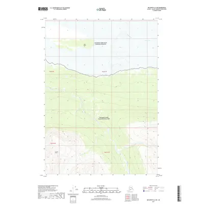
2017 Map of McCarthy A-4 SW
USGS Topo · Published 2017About this map
The Chitina River flows through a massive glacial valley in this section of the Alaskan wilderness, where the Wrangell-Saint Elias National Preserve transitions into the Wrangell-Saint Elias National Park. The landscape is defined by the stark descent from the peaks of the Granite Range into the broad, braided riverbeds below. The Kiagna River and its tributaries, including the E Fork Kiagna River and Bearhole Cr, carve deep paths through the high-elevation terrain to reach the Chitina. Notable landmarks like Bear Island stand as isolated high ground within the river's wide floodplain, illustrating the dynamic hydrology of the region before it enters the narrow passage near Canyon Creek.
Find a feature on this map
14 named features on this map. Tap any name to fly to it.
Don’t see what you’re looking for? This feature index may not catch every label — zoom into the map to look around manually.
Map Details
Editions of this 2017 McCarthy A-4 SW Map
This is the sole edition of this map. No revisions or reprints were ever made.
Other maps of this area

1950 · Bering Glacier
USGS Topo · 1:250,000

1951 · McCarthy
USGS Topo · 1:250,000

1951 · Bering Glacier
USGS Topo · 1:250,000

1959 · McCarthy A-4
USGS Topo · 1:63,360

1959 · McCarthy A-5
USGS Topo · 1:63,360

1959 · Bering Glacier
USGS Topo · 1:250,000

1960 · McCarthy
USGS Topo · 1:250,000

1984 · Bering Glacier D-4
USGS Topo · 1:63,360

1984 · Bering Glacier D-5
USGS Topo · 1:63,360
1994 · McCarthy A-4
USGS Topo · 1:63,360