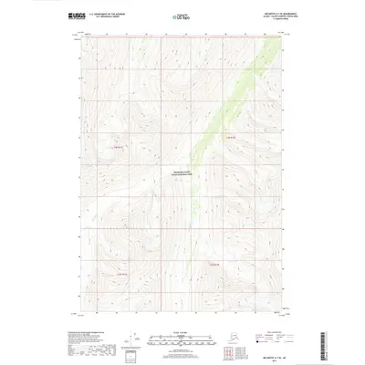
2017 Map of McCarthy A-7 SE
USGS Topo · Published 2017About this map
Wrangell-Saint Elias National Park encompasses the entirety of this interior Alaskan landscape, which is defined by high-elevation ridges and glacial drainages. The topography is dominated by the steep valley carved by Monahan Cr, which flows northward through the center of the quadrangle. Several smaller tributaries, including Gold Cr from the northeast and Picket Cr from the west, feed into this central drainage system. The drainage pattern of Golconda Cr in the southwest corner suggests a landscape dictated by heavy seasonal runoff and glacial history. This survey captures a wild stretch of the eastern Chugach or Wrangell mountains before modern infrastructure reached this sector of the park, showing only natural contours and the original watercourses that have shaped the region.
Find a feature on this map
5 named features on this map. Tap any name to fly to it.
Don’t see what you’re looking for? This feature index may not catch every label — zoom into the map to look around manually.
Map Details
Editions of this 2017 McCarthy A-7 SE Map
This is the sole edition of this map. No revisions or reprints were ever made.
Other maps of this area

1950 · Bering Glacier
USGS Topo · 1:250,000

1951 · McCarthy
USGS Topo · 1:250,000

1951 · Bering Glacier
USGS Topo · 1:250,000

1959 · McCarthy A-6
USGS Topo · 1:63,360

1959 · Bering Glacier
USGS Topo · 1:250,000

1959 · McCarthy A-7
USGS Topo · 1:63,360

1960 · McCarthy
USGS Topo · 1:250,000
1984 · Bering Glacier D-7
USGS Topo · 1:63,360
1984 · Bering Glacier D-6
USGS Topo · 1:63,360

1994 · McCarthy A-6
USGS Topo · 1:63,360