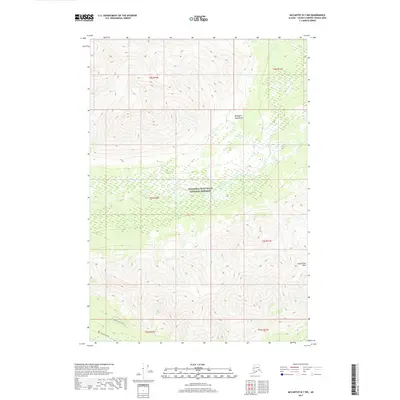
2017 Map of McCarthy B-7 NW
USGS Topo · Published 2017About this map
The Wrangell Mountains dominate the northern landscape of this interior Alaskan territory, where high-altitude ridges give way to the glacial drainage of the Gilahina River. This 2017 study within the Wrangell-Saint Elias National Preserve documents a region defined by its dramatic relief and sparse human footprint. In the southern reach of the quadrangle, the historic McCarthy Road provides the primary corridor for access, skirting the base of the Crystalline Hills. The map illustrates the specialized recreational and wilderness infrastructure of the modern era, specifically marking the Crystalline Hills Trail as it winds through the foothills. The arrangement of township and range lines, such as t5s r10e and t6s r11e, provides a formal cadastral overlay to a landscape otherwise shaped by natural hydrology and alpine terrain.
Find a feature on this map
12 named features on this map. Tap any name to fly to it.
Don’t see what you’re looking for? This feature index may not catch every label — zoom into the map to look around manually.
Map Details
Editions of this 2017 McCarthy B-7 NW Map
This is the sole edition of this map. No revisions or reprints were ever made.
Other maps of this area

1951 · McCarthy
USGS Topo · 1:250,000

1951 · McCarthy C-8
USGS Topo · 1:63,360

1951 · McCarthy B-8
USGS Topo · 1:63,360

1959 · McCarthy C-7
USGS Topo · 1:63,360

1959 · McCarthy B-7
USGS Topo · 1:63,360

1960 · McCarthy
USGS Topo · 1:250,000
1995 · McCarthy B-7
USGS Topo · 1:63,360

1995 · McCarthy B-8
USGS Topo · 1:63,360
1995 · McCarthy C-7
USGS Topo · 1:63,360
1995 · McCarthy C-8
USGS Topo · 1:63,360