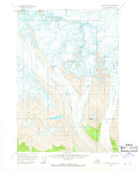
1959 Map of McCarthy C-6
USGS Topo · Published 1969About this map
Regal Mine and Erie Mine represent the industrial footprint of the copper region at the close of the 1950s. Located on the slopes of Donoho Peak and near the massive moving ice of the Root Glacier, these sites are connected by a Tractor Trail that skirts the glacial moraine. The landscape is defined by the convergence of the Kennicott Glacier and Gates Glacier, creating a terrain where high-elevation landmarks like Atna Peaks and Parka Peak rise above the surrounding ice fields.
Find a feature on this map
19 named features on this map. Tap any name to fly to it.
Don’t see what you’re looking for? This feature index may not catch every label — zoom into the map to look around manually.
Map Details
Editions of this 1959 McCarthy C-6 Map
3 editions found
Other maps of this area

1951 · McCarthy
USGS Topo · 1:250,000

1959 · McCarthy B-6
USGS Topo · 1:63,360

1959 · McCarthy C-5
USGS Topo · 1:63,360

1959 · McCarthy B-5
USGS Topo · 1:63,360

1959 · McCarthy D-7
USGS Topo · 1:63,360

1959 · McCarthy C-6
USGS Topo · 1:63,360

1959 · McCarthy C-7
USGS Topo · 1:63,360

1959 · McCarthy B-7
USGS Topo · 1:63,360

1960 · McCarthy D-6
USGS Topo · 1:63,360
1960 · McCarthy D-5
USGS Topo · 1:63,360