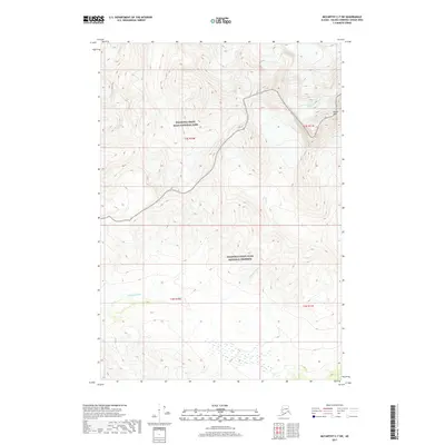
2017 Map of McCarthy C-7 SW
USGS Topo · Published 2017About this map
Wrangell-Saint Elias National Park and the adjacent Wrangell-Saint Elias National Preserve dominate this high-altitude landscape in the Valdez-Cordova Census Area. The terrain is defined by extreme glacial activity and steep drainage systems, most notably where the Kuskulana Glacier descends from the northeast corner near the prominent Castle Peak. This ice-driven environment feeds several water systems, including the headwaters of Mill Cr and the westward-flowing Chokosna River. The map primarily serves as a record of natural hydrology and glacial positions within these protected lands, capturing a wilderness where the lack of human infrastructure or roads emphasizes the sheer scale of the Alaskan interior's mountain and ice fields.
Find a feature on this map
10 named features on this map. Tap any name to fly to it.
Don’t see what you’re looking for? This feature index may not catch every label — zoom into the map to look around manually.
Map Details
Editions of this 2017 McCarthy C-7 SW Map
This is the sole edition of this map. No revisions or reprints were ever made.
Other maps of this area

1951 · McCarthy
USGS Topo · 1:250,000

1951 · McCarthy C-8
USGS Topo · 1:63,360

1951 · McCarthy B-8
USGS Topo · 1:63,360

1959 · McCarthy C-7
USGS Topo · 1:63,360

1959 · McCarthy B-7
USGS Topo · 1:63,360

1960 · McCarthy
USGS Topo · 1:250,000
1995 · McCarthy B-7
USGS Topo · 1:63,360

1995 · McCarthy B-8
USGS Topo · 1:63,360
1995 · McCarthy C-7
USGS Topo · 1:63,360
1995 · McCarthy C-8
USGS Topo · 1:63,360