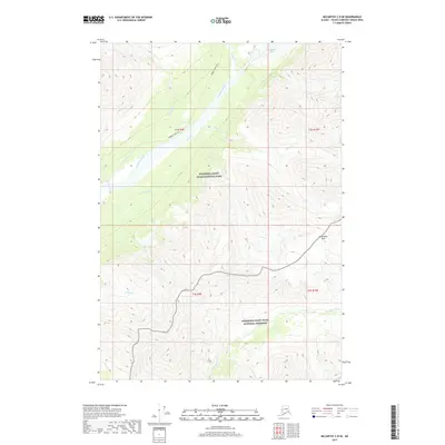
2017 Map of McCarthy C-8 SE
USGS Topo · Published 2017About this map
Wrangell-Saint Elias National Park and the adjacent Wrangell-Saint Elias National Preserve dominate this high-altitude landscape in the Unorganized Borough. The terrain is defined by the massive drainage system of the Kuskulana River, which is fed by the Kuskulana Glacier in the north. This 2017 survey illustrates a wilderness primarily accessible by historic routes like the Nugget Creek Trail, which follows the northern contours of the river valley. The map documents the intricate network of glacial tributaries, including Porcupine Cr, Slatka Cr, and MacDougall Cr, as they flow from steep ridges toward the main river channel. To the south, the Chokosna River carves through the preserve, while Kuskulana Pass provides a natural corridor through the interior peaks, marking a critical point of passage in this glaciated environment.
Find a feature on this map
18 named features on this map. Tap any name to fly to it.
Don’t see what you’re looking for? This feature index may not catch every label — zoom into the map to look around manually.
Map Details
Editions of this 2017 McCarthy C-8 SE Map
This is the sole edition of this map. No revisions or reprints were ever made.
Other maps of this area

1951 · McCarthy
USGS Topo · 1:250,000

1951 · McCarthy C-8
USGS Topo · 1:63,360

1951 · McCarthy B-8
USGS Topo · 1:63,360

1959 · McCarthy C-7
USGS Topo · 1:63,360

1959 · McCarthy B-7
USGS Topo · 1:63,360

1960 · McCarthy
USGS Topo · 1:250,000
1995 · McCarthy B-7
USGS Topo · 1:63,360

1995 · McCarthy B-8
USGS Topo · 1:63,360
1995 · McCarthy C-7
USGS Topo · 1:63,360
1995 · McCarthy C-8
USGS Topo · 1:63,360