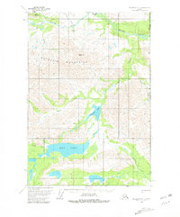
1959 Map of McCarthy D-1
USGS Topo · Published 1981About this map
The Nutzotin Mountains dominate this high-altitude landscape along the Alaska Yukon border, where the headwaters of the White River system begin to take shape. Surveyed in the late 1950s, the terrain reveals a remote wilderness defined by glacially influenced water bodies like Ptarmigan Lake and the expansive Rock Lake. The presence of Horsefeld and a lone Cabin near the lake suggests a seasonal or historic human footprint, likely tied to early trapping or prospecting in the region.
Find a feature on this map
22 named features on this map. Tap any name to fly to it.
Don’t see what you’re looking for? This feature index may not catch every label — zoom into the map to look around manually.
Map Details
Editions of this 1959 McCarthy D-1 Map
2 editions found
Other maps of this area

1950 · Nabesna
USGS Topo · 1:250,000

1951 · McCarthy
USGS Topo · 1:250,000

1951 · Nabesna
USGS Topo · 1:250,000

1959 · McCarthy D-1
USGS Topo · 1:63,360

1959 · McCarthy D-2
USGS Topo · 1:63,360

1959 · Nabesna A-1
USGS Topo · 1:63,360

1959 · McCarthy C-1
USGS Topo · 1:63,360

1959 · McCarthy C-2
USGS Topo · 1:63,360

1960 · Nabesna
USGS Topo · 1:250,000

1960 · McCarthy
USGS Topo · 1:250,000