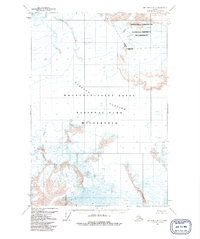
1959 Map of McCarthy D-7
USGS Topo · Published 1992About this map
Nabesna Glacier dominates this high-altitude landscape, its immense frozen expanse marked by intricate fields of Crevasses. Surveyed in the late 1950s, the map reveals a wilderness of ice and rock before the formal establishment of contemporary conservation boundaries. The division between the Wrangell-Saint Elias National Park (Wilderness) and the Wrangell-Saint Elias National Preserve (Wilderness) is clearly delineated, alongside the official Base Line survey mark. This topographic record is focused entirely on the raw physical geography of the region, providing a baseline for understanding glacial movement and the stark terrain of the Wrangell Mountains at mid-century.
Find a feature on this map
6 named features on this map. Tap any name to fly to it.
Don’t see what you’re looking for? This feature index may not catch every label — zoom into the map to look around manually.
Map Details
Editions of this 1959 McCarthy D-7 Map
2 editions found
Other maps of this area

1950 · Nabesna
USGS Topo · 1:250,000

1951 · McCarthy
USGS Topo · 1:250,000

1951 · Nabesna
USGS Topo · 1:250,000

1951 · McCarthy C-8
USGS Topo · 1:63,360

1959 · Nabesna A-6
USGS Topo · 1:63,360

1959 · McCarthy D-7
USGS Topo · 1:63,360

1959 · Nabesna A-5
USGS Topo · 1:63,360

1959 · McCarthy C-6
USGS Topo · 1:63,360

1959 · McCarthy C-7
USGS Topo · 1:63,360

1960 · McCarthy D-8
USGS Topo · 1:63,360