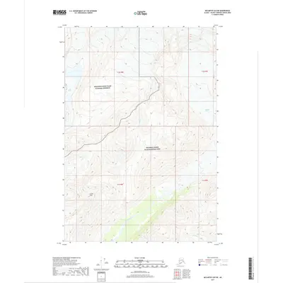
2017 Map of McCarthy D-8 SW
USGS Topo · Published 2017About this map
Scotty Peak rises as a prominent landmark in this interior Alaskan wilderness, situated at the jurisdictional boundary between the Wrangell-Saint Elias National Preserve and the Wrangell-Saint Elias National Park. The landscape is defined by its glacial hydrology, where the massive Long Glacier and Kluvesna Glacier feed a network of drainages including Fall Cr, Clear Cr, and the braided channel of the Kluvesna River. In the southern portion of the sheet, the river valley widens, joined by tributaries such as Mineral Cr and Surprise Cr. This 2017 survey illustrates the complex topographic relief of the Copper River basin region, showing the high-elevation snowfields and the intricate drainage patterns that characterize the transition from ice-capped peaks to alluvial valley floors.
Find a feature on this map
14 named features on this map. Tap any name to fly to it.
Don’t see what you’re looking for? This feature index may not catch every label — zoom into the map to look around manually.
Map Details
Editions of this 2017 McCarthy D-8 SW Map
This is the sole edition of this map. No revisions or reprints were ever made.
Other maps of this area

1951 · McCarthy
USGS Topo · 1:250,000

1951 · McCarthy C-8
USGS Topo · 1:63,360

1951 · Valdez C-1
USGS Topo · 1:63,360

1952 · Valdez
USGS Topo · 1:250,000

1953 · Valdez C-1
USGS Topo · 1:63,360

1959 · Valdez D-1
USGS Topo · 1:63,360

1960 · McCarthy D-8
USGS Topo · 1:63,360

1960 · McCarthy
USGS Topo · 1:250,000

1960 · Valdez
USGS Topo · 1:250,000
1995 · McCarthy C-8
USGS Topo · 1:63,360