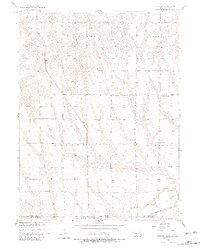
1957 Map of McCook SE
USGS Topo · Published 1982About this map
The Nebraska-Kansas state line bisects this agricultural landscape, recorded during the late 1950s as part of the Missouri River Basin development program. The topography is defined by the winding course of Beaver Creek and its tributary, Brushy Creek, which carve through the high plains of Red Willow and Decatur Counties. This area is marked by a network of rural schoolhouses, including College Hill Sch, Prairie View Sch, and numbered districts like School No 25, suggesting the decentralized nature of local education before modern consolidation.
Find a feature on this map
17 named features on this map. Tap any name to fly to it.
Don’t see what you’re looking for? This feature index may not catch every label — zoom into the map to look around manually.
Map Details
Editions of this 1957 McCook SE Map
2 editions found
Other maps of this area

1951 · Oberlin
USGS Topo · 1:62,500

1951 · Kanona
USGS Topo · 1:62,500

1954 · McCook
USGS Topo · 1:250,000

1954 · Goodland
USGS Topo · 1:250,000

1956 · Goodland
USGS Topo · 1:250,000

1957 · McCook
USGS Topo · 1:250,000

1957 · Goodland
USGS Topo · 1:250,000

1957 · McCook SW
USGS Topo · 1:24,000

1957 · Danbury
USGS Topo · 1:24,000

1957 · McCook SE
USGS Topo · 1:24,000