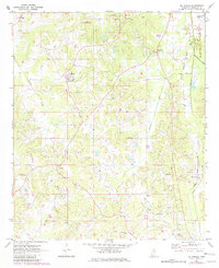
1972 Map of McDonald
USGS Topo · Published 1982About this map
The Choctaw Indian Reservation dominates the northern reaches of this Neshoba County landscape, reflecting the enduring presence of the Mississippi Band of Choctaw Indians. Photogrammetric methods from 1970 reveal a rural network of small communities and social centers, including the Fairground near Coldwater and several country churches like St Paul Ch and Pine Grove Ch. The eastern edge of the map follows a distinct drainage and transport corridor, where the Kentawka Canal and Gulf Central Illinois Canal parallel the rail line serving Deemer (Station) and McDonald. This industrial and agricultural water management system contrasts with the meandering path of Beasha Creek to the west. Genealogists can find numerous family-named landmarks and burial grounds, such as Morrow Memorial Cem and Sand Hill Cem, providing a detailed view of the area's mid-century rural distribution.
Find a feature on this map
27 named features on this map. Tap any name to fly to it.
Don’t see what you’re looking for? This feature index may not catch every label — zoom into the map to look around manually.
Map Details
Editions of this 1972 McDonald Map
2 editions found
Other maps of this area

1953 · Meridian
USGS Topo · 1:250,000

1957 · Meridian
USGS Topo · 1:250,000

1962 · Edinburg
USGS Topo · 1:62,500

1965 · Meridian
USGS Topo · 1:250,000

1972 · Pearl River
USGS Topo · 1:24,000

1972 · Deemer
USGS Topo · 1:24,000

1972 · Union East
USGS Topo · 1:24,000
1972 · Philadelphia
USGS Topo · 1:24,000

1972 · Madden
USGS Topo · 1:24,000
1972 · Sebastopol
USGS Topo · 1:24,000