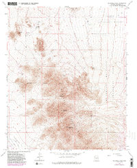
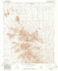
1965 Map of McDowell Peak
USGS Topo · Published 1985About this map
MC Dowell Mountains dominate this 1960s survey of the high desert landscape northeast of Phoenix. The map reveals a transition between the federally protected lands of the Tonto National Forest and the expanding boundaries of the Scottsdale Corporate Boundary. Significant mining history is preserved through labels for the Dixie Mine and various Prospects scattered across the western slopes of East End. Topographical landmarks like Pinnacle Peak and the high summit of Thompson Peak provide orientation for the area's complex relief. The mapping of numerous Wells and a Water Tank indicates the vital importance of water management in Paradise Valley as ranching and early residential development began to characterize the region. This edition includes 1980s updates, showing the evolving infrastructure through a Radio Facility and a network of Trails and Jeep Trails.
Find a feature on this map
22 named features on this map. Tap any name to fly to it.
Don’t see what you’re looking for? This feature index may not catch every label — zoom into the map to look around manually.
Map Details
Editions of this 1965 McDowell Peak Map
6 editions found

Other maps of this area

1904 · Camelback
USGS Topo · 1:62,500

1904 · Ft. McDowell
USGS Topo · 1:62,500

1906 · Camelsback
USGS Topo · 1:62,500

1906 · Ft. McDowell
USGS Topo · 1:62,500

1930 · Cave Creek
USGS Topo · 1:125,000

1939 · Cave Creek
USGS Topo · 1:125,000

1954 · Mesa
USGS Topo · 1:250,000

1957 · Mesa
USGS Topo · 1:250,000

1958 · Mesa
USGS Topo · 1:250,000

1960 · Mesa
USGS Topo · 1:250,000
Featured Places
- Scottsdale, AZ
- Fountain Hills, AZ
- Maricopa County, AZ
- United States
- Pinnacle Peak Heights V-VI, Scottsdale