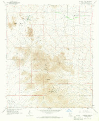
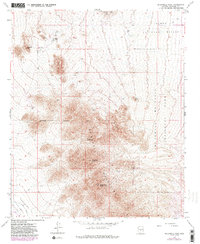
1965 Map of McDowell Peak
USGS Topo · Published 1967About this map
Mc Dowell Mountains dominate this mid-century survey, rising sharply above the desert floor of northern Paradise Valley. The landscape is a study in the intersection of expanding municipal boundaries and protected wilderness, with the Scottsdale Corporate Boundary cutting across the mountain slopes and through Mc Dowell Peak. Settlement is sparse at this date, centered primarily around Reata Pass, while the presence of the Dixie Mine and various Prospects indicate the area's legacy of mineral exploration.
Find a feature on this map
24 named features on this map. Tap any name to fly to it.
Don’t see what you’re looking for? This feature index may not catch every label — zoom into the map to look around manually.
Map Details
Editions of this 1965 McDowell Peak Map
6 editions found

Other maps of this area

1904 · Camelback
USGS Topo · 1:62,500

1904 · Ft. McDowell
USGS Topo · 1:62,500

1906 · Camelsback
USGS Topo · 1:62,500

1906 · Ft. McDowell
USGS Topo · 1:62,500

1930 · Cave Creek
USGS Topo · 1:125,000

1939 · Cave Creek
USGS Topo · 1:125,000

1954 · Mesa
USGS Topo · 1:250,000

1957 · Mesa
USGS Topo · 1:250,000

1958 · Mesa
USGS Topo · 1:250,000

1960 · Mesa
USGS Topo · 1:250,000
Featured Places
- Scottsdale, AZ
- Fountain Hills, AZ
- Maricopa County, AZ
- United States
- Pinnacle Peak Heights V-VI, Scottsdale