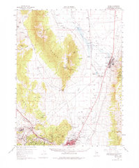
1958 Map of McGill
USGS Topo · Published 1975About this map
Industrial activity dominates the landscape of Steptoe Valley in the late 1950s, centered on the massive Copper Smelter at McGill. The map reveals a complex infrastructure of resource extraction and processing, featuring an extensive Tailings Area, a Pumphouse, and a dedicated Flume. To the southwest, the mining settlements of Ruth and Lane City are linked by the Nevada Northern railroad, which threads through the mountains past Keystone Junction. The mapping of small hills like Willard Hill and Ada Hill near the mining pits underscores the heavy geographic transformation of this copper-rich corridor. Away from the smelters, the valley floor maintains its ranching character at Georgetown Ranch and Lusetti Ranch, while the Egan Range to the west remains largely defined by natural landmarks like Heusser Mtn and Lusetti Canyon.
Find a feature on this map
87 named features on this map. Tap any name to fly to it.
Don’t see what you’re looking for? This feature index may not catch every label — zoom into the map to look around manually.
Map Details
Editions of this 1958 McGill Map
2 editions found
Other maps of this area

1952 · Ely
USGS Topo · 1:125,000

1956 · Ely
USGS Topo · 1:250,000

1958 · McGill
USGS Topo · 1:24,000

1958 · Ruth
USGS Topo · 1:24,000

1958 · East Ely
USGS Topo · 1:24,000

1958 · Comins Lake
USGS Topo · 1:24,000

1958 · Ely
USGS Topo · 1:62,500

1958 · McGill
USGS Topo · 1:62,500

1958 · Reipetown
USGS Topo · 1:24,000

1958 · Giroux Wash
USGS Topo · 1:24,000