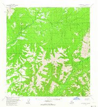
1954 Map of McGrath A-5
USGS Topo · Published 1964About this map
Tatlawiksuk River and Cheeneetnuk River define the hydrology of this interior Alaskan landscape as it was documented in the mid-1950s. The terrain transitions from broad, swampy lowlands in the north to increasingly complex, high-elevation ridges in the south. These unsurveyed lands, part of the Seward Meridian, are shown as they appeared before extensive modern human impact, with no roads or trails recorded in the area at the time of the 1954 field annotation. The intricate contour work illustrates the steep drainages feeding the rivers, while the portrayal of wetlands reveals the low-lying basins typical of the Yukon-Koyukuk region. This document serves as a baseline for the natural geography of the McGrath quadrangle during the era of early photogrammetric aerial mapping.
Find a feature on this map
2 named features on this map. Tap any name to fly to it.
Don’t see what you’re looking for? This feature index may not catch every label — zoom into the map to look around manually.
Map Details
Editions of this 1954 McGrath A-5 Map
2 editions found
Other maps of this area

1949 · McGrath
USGS Topo · 1:250,000

1950 · McGrath
USGS Topo · 1:250,000

1951 · Lime Hills
USGS Topo · 1:250,000

1954 · McGrath B-4
USGS Topo · 1:63,360

1954 · McGrath B-6
USGS Topo · 1:63,360

1954 · McGrath A-4
USGS Topo · 1:63,360
1954 · Lime Hills D-7
USGS Topo · 1:63,360

1954 · Lime Hills D-6
USGS Topo · 1:63,360

1954 · McGrath B-5
USGS Topo · 1:63,360
1954 · McGrath A-5
USGS Topo · 1:63,360