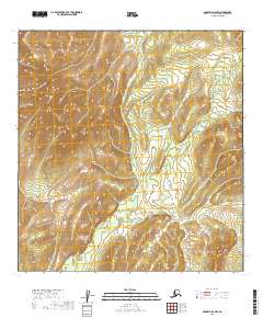
2019 Map of McGrath A-6 NW
USGS Topo · Published 2019About this map
Township lines of T25n R36w, T25n R35w, and T24n R36w divide this interior Alaskan landscape within the Yukon-Koyukuk Census Area. The terrain is defined by a dense network of high ridges and narrow drainage basins, primarily captured through precise contour intervals rather than named settlements or cultural landmarks. This 2019 survey by the U.S. Geological Survey focuses on the structural topography of the McGrath A-6 NW quadrangle, providing a technical visualization of the land's elevation and watershed patterns. Without roads, buildings, or named water bodies, the map emphasizes the raw physical geography and the legal Public Land Survey System boundaries that organize this remote territory.
Find a feature on this map
5 named features on this map. Tap any name to fly to it.
Don’t see what you’re looking for? This feature index may not catch every label — zoom into the map to look around manually.
Map Details
Editions of this 2019 McGrath A-6 NW Map
This is the sole edition of this map. No revisions or reprints were ever made.
Other maps of this area

1949 · McGrath
USGS Topo · 1:250,000

1950 · McGrath
USGS Topo · 1:250,000

1951 · Iditarod
USGS Topo · 1:250,000

1954 · Iditarod B-1
USGS Topo · 1:63,360

1954 · Iditarod A-1
USGS Topo · 1:63,360

1954 · McGrath B-6
USGS Topo · 1:63,360
1954 · McGrath A-6
USGS Topo · 1:63,360

1956 · Iditarod
USGS Topo · 1:250,000

1958 · McGrath
USGS Topo · 1:250,000
2019 · McGrath B-6 SW
USGS Topo · 1:25,000