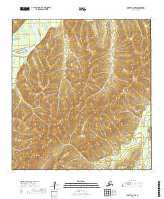
2019 Map of McGrath B-6 NW
USGS Topo · Published 2019About this map
The Kuskokwim River enters the northwestern corner of this territory, providing a major drainage route through a landscape primarily defined by high-elevation contours. The topographical data for this region in the Yukon-Koyukuk Census Area reveals a complex system of ridges and valleys that dictate the flow of smaller tributaries. Toward the southeast, the First Fork Selatna River snakes through the lower elevations, eventually joining the larger regional water systems. This map captures the unpopulated interior of Alaska, where the Public Land Survey System grids, such as t27n r36w and t27n r35w, provide the only formal structure across the expansive terrain. The absence of named settlements or roads underscores the wilderness character of the area, emphasizing its importance for hydrological study and remote navigation.
Find a feature on this map
8 named features on this map. Tap any name to fly to it.
Don’t see what you’re looking for? This feature index may not catch every label — zoom into the map to look around manually.
Map Details
Editions of this 2019 McGrath B-6 NW Map
This is the sole edition of this map. No revisions or reprints were ever made.
Other maps of this area

1949 · McGrath
USGS Topo · 1:250,000

1950 · McGrath
USGS Topo · 1:250,000

1951 · Iditarod
USGS Topo · 1:250,000

1954 · Iditarod B-1
USGS Topo · 1:63,360

1954 · McGrath B-6
USGS Topo · 1:63,360

1954 · McGrath C-6
USGS Topo · 1:63,360
1956 · Iditarod C-1
USGS Topo · 1:63,360

1956 · Iditarod
USGS Topo · 1:250,000

1958 · McGrath
USGS Topo · 1:250,000
2019 · McGrath B-6 SW
USGS Topo · 1:25,000