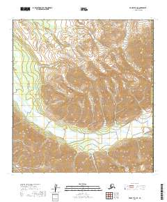
2019 Map of McGrath C-1 SE
USGS Topo · Published 2019About this map
The Alaska Range dominates the northern reaches of this topographic study, where steep ridgelines meet the headwaters of the Dillinger River. This interior landscape is defined by the high-elevation transition between the Alaska Range and the Kichatna Mountains to the southwest. The map documents the political boundary between the Yukon-Koyukuk Census Area and the Matanuska-Susitna Borough, which cuts north-to-south through the high peaks. The drainage patterns of the Dillinger River illustrate a classic glacial mountain valley system, with tight contouring indicating significant vertical relief. Free of named settlements or infrastructure, the area remains an expanse of public land managed under the Public Land Survey System, including portions of t28n r21w, t28n r20w, t29n r21w, and t29n r20w.
Find a feature on this map
8 named features on this map. Tap any name to fly to it.
Don’t see what you’re looking for? This feature index may not catch every label — zoom into the map to look around manually.
Map Details
Editions of this 2019 McGrath C-1 SE Map
This is the sole edition of this map. No revisions or reprints were ever made.
Other maps of this area

1949 · McGrath
USGS Topo · 1:250,000

1950 · McGrath
USGS Topo · 1:250,000

1950 · Talkeetna
USGS Topo · 1:250,000

1951 · Talkeetna
USGS Topo · 1:250,000

1958 · Talkeetna B-6
USGS Topo · 1:63,360

1958 · Talkeetna C-6
USGS Topo · 1:63,360

1958 · McGrath B-1
USGS Topo · 1:63,360

1958 · McGrath C-1
USGS Topo · 1:63,360

1958 · Talkeetna
USGS Topo · 1:250,000

1958 · McGrath
USGS Topo · 1:250,000