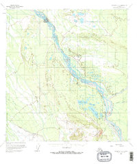
1958 Map of McGrath C-2
USGS Topo · Published 1964About this map
The South Fork Kuskokwim River defines the drainage of this interior Alaskan landscape, joined by the Dillinger River and Jones River as they flow through a complex system of braided channels and marshes. This 1950s environment shows early bush aviation and wilderness outposts established south of the main river course. Central to the area's activity is Farewell Lake, which hosts the Farewell Lake Lodge and is flanked by smaller bodies like Steele Lake and Submarine Lake. To the south, Farewell Mountain rises above the lowlands, overlooking the Farewell Airport and its associated Landing Strip and Radio Towers. This transport hub serves as a critical junction for the remote region, connected by a network of seasonal routes including a Winter Trail and a Jeep Trail that traverse the marshy flats.
Find a feature on this map
18 named features on this map. Tap any name to fly to it.
Don’t see what you’re looking for? This feature index may not catch every label — zoom into the map to look around manually.
Map Details
Editions of this 1958 McGrath C-2 Map
2 editions found
Other maps of this area

1949 · McGrath
USGS Topo · 1:250,000

1950 · McGrath
USGS Topo · 1:250,000

1954 · McGrath D-3
USGS Topo · 1:63,360

1954 · McGrath C-3
USGS Topo · 1:63,360

1958 · McGrath B-1
USGS Topo · 1:63,360

1958 · McGrath B-2
USGS Topo · 1:63,360

1958 · McGrath D-2
USGS Topo · 1:63,360

1958 · McGrath C-1
USGS Topo · 1:63,360

1958 · McGrath C-2
USGS Topo · 1:63,360
1958 · McGrath B-3
USGS Topo · 1:63,360