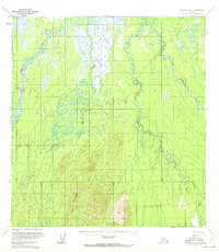
1953 Map of McGrath C-4
USGS Topo · Published 1972About this map
Lone Mountain dominates the central southern portion of this landscape, rising above an intricate network of waterways in the Kuskokwim region. The hydrology is remarkably complex, characterized by the wide, meandering Kuskokwim River and its major tributaries, including the Big River and the Middle Fork. This 1953 data shows a transition from the lower river flats into more elevated terrain near Khishatynik Creek. The map documents the natural state of the interior before any significant infrastructure development, emphasizing the labyrinthine nature of the Windy Fork and the surrounding marshlands. It serves as a primary record of the Alaskan wilderness as it appeared during the mid-century mapping efforts conducted by the Geological Survey and the Bureau of Land Management.
Find a feature on this map
6 named features on this map. Tap any name to fly to it.
Don’t see what you’re looking for? This feature index may not catch every label — zoom into the map to look around manually.
Map Details
Editions of this 1953 McGrath C-4 Map
2 editions found
Other maps of this area

1949 · McGrath
USGS Topo · 1:250,000

1950 · McGrath
USGS Topo · 1:250,000

1953 · McGrath D-5
USGS Topo · 1:63,360

1953 · McGrath C-4
USGS Topo · 1:63,360

1953 · McGrath D-4
USGS Topo · 1:63,360

1954 · McGrath B-4
USGS Topo · 1:63,360

1954 · McGrath D-3
USGS Topo · 1:63,360

1954 · McGrath C-3
USGS Topo · 1:63,360

1954 · McGrath B-5
USGS Topo · 1:63,360
1955 · McGrath C-5
USGS Topo · 1:63,360