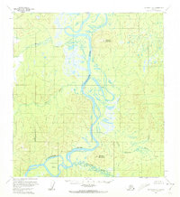
1954 Map of McGrath C-6
USGS Topo · Published 1972About this map
The Kuskokwim River dominates this interior Alaskan landscape, winding through a complex system of sloughs and sandbars as it appeared in the mid-1950s. The river's path is marked by features such as Nunivak Bar and the confluence with the Selatna River and Little River. This survey captures the wilderness character of the region before significant modern development, emphasizing the natural topography and the importance of water systems for navigation and survival in the subarctic. Rising above the low-lying river valley are prominent landmarks including Vinasale Mountain and Selatna Mountain, providing essential orienting points for travelers. Smaller tributaries like Beaver Creek and Black River feed into the main channel, illustrating the dense hydrological network of the Yukon-Koyukuk region. The area around Vinasale represents a site of historical interest in a region where seasonal movement and river access shaped the settlement patterns of the era.
Find a feature on this map
10 named features on this map. Tap any name to fly to it.
Don’t see what you’re looking for? This feature index may not catch every label — zoom into the map to look around manually.
Map Details
Editions of this 1954 McGrath C-6 Map
2 editions found
Other maps of this area

1949 · McGrath
USGS Topo · 1:250,000

1950 · McGrath
USGS Topo · 1:250,000

1951 · Iditarod
USGS Topo · 1:250,000

1953 · McGrath D-5
USGS Topo · 1:63,360

1954 · McGrath D-6
USGS Topo · 1:63,360

1954 · Iditarod B-1
USGS Topo · 1:63,360

1954 · McGrath B-6
USGS Topo · 1:63,360

1954 · McGrath C-6
USGS Topo · 1:63,360

1954 · McGrath B-5
USGS Topo · 1:63,360
1954 · Iditarod D-1
USGS Topo · 1:63,360