
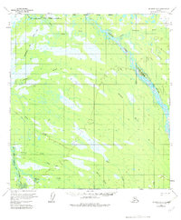
1954 Map of McGrath D-3
USGS Topo · Published 1963About this map
The South Fork Kuskokwim River snakes through a low-lying landscape defined by extensive wetlands and seasonal watercourses in this mid-century survey of the Alaska interior. The river's braided channels are joined by the Tonzona River and Salmon River, illustrating the complex drainage patterns of the Yukon-Koyukuk region. A notable cultural landmark is Nikolai (Site), located along the riverbanks, representing a specific point of human habitation or activity in a territory otherwise dominated by natural hydrology.
Find a feature on this map
9 named features on this map. Tap any name to fly to it.
Don’t see what you’re looking for? This feature index may not catch every label — zoom into the map to look around manually.
Map Details
Editions of this 1954 McGrath D-3 Map
2 editions found
Other maps of this area

1949 · McGrath
USGS Topo · 1:250,000

1950 · Medfra
USGS Topo · 1:250,000

1950 · McGrath
USGS Topo · 1:250,000

1953 · McGrath C-4
USGS Topo · 1:63,360

1953 · McGrath D-4
USGS Topo · 1:63,360

1954 · McGrath C-3
USGS Topo · 1:63,360

1954 · Medfra A-3
USGS Topo · 1:63,360

1958 · McGrath D-2
USGS Topo · 1:63,360

1958 · Medfra A-2
USGS Topo · 1:63,360

1958 · McGrath C-2
USGS Topo · 1:63,360