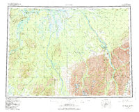
1958 Map of McGrath
USGS Topo · Published 1984About this map
The Kuskokwim River serves as the central artery for this interior Alaskan region, anchored by the settlement of McGrath. This survey shows the area as a vital transportation hub during the mid-twentieth century, featuring the McGrath Seaplane Base and the Tatalina Air Force Sta near Sterling Landing. The map documents a transition from traditional river-and-trail travel to aviation-dependent logistics, tracing the historic Iditarod Trail alongside modern airstrips like the Farewell Airport and the White Mtn Mine Landing Strip. Remote outposts and seasonal nodes are prominent, including the Big River Roadhouse, Rohn Roadhouse, and Farewell Lake Lodge. To the southeast, the landscape rises into the Terra Cotta Mountains and Teocalli Mountains, where high-altitude passages like Rainy Pass and Houston Pass mark the drainage divides between the interior and the coast.
Find a feature on this map
98 named features on this map. Tap any name to fly to it.
Don’t see what you’re looking for? This feature index may not catch every label — zoom into the map to look around manually.
Map Details
Editions of this 1958 McGrath Map
3 editions found

Other maps of this area

1949 · Tyonek
USGS Topo · 1:250,000

1949 · McGrath
USGS Topo · 1:250,000

1950 · Medfra
USGS Topo · 1:250,000

1950 · Sleetmute
USGS Topo · 1:250,000

1950 · McGrath
USGS Topo · 1:250,000

1950 · Talkeetna
USGS Topo · 1:250,000

1951 · Talkeetna
USGS Topo · 1:250,000

1951 · Ophir
USGS Topo · 1:250,000

1951 · Tyonek
USGS Topo · 1:250,000

1951 · Lime Hills
USGS Topo · 1:250,000