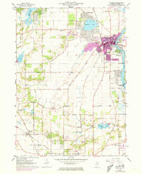
1963 Map of McHenry
USGS Topo · Published 1973About this map
The Fox River corridor anchors this portrait of McHenry County, where the river winds past a string of waterfront developments including Riverstream, Emerald Park, and McHenry Shores. The town of McHenry serves as a regional hub, its urban core shown in purple revision shading, while the surrounding landscape transitions into the rural townships of Greenwood, Dorr, and Nunda. Significant gravel operations are visible throughout the region, particularly near the Chicago and North Western rail line and in the vicinity of Barreville.
Find a feature on this map
69 named features on this map. Tap any name to fly to it.
Don’t see what you’re looking for? This feature index may not catch every label — zoom into the map to look around manually.
Map Details
Editions of this 1963 McHenry Map
3 editions found
Other maps of this area

1920 · Grays Lake
USGS Topo · 1:62,500

1923 · Grays Lake
USGS Topo · 1:62,500

1923 · Barrington
USGS Topo · 1:62,500

1925 · Elgin
USGS Topo · 1:62,500

1926 · Mc Henry
USGS Topo · 1:62,500

1935 · Barrington
USGS Topo · 1:62,500

1940 · Elgin
USGS Topo · 1:62,500

1944 · McHenry
USGS Topo · 1:62,500

1954 · Rockford
USGS Topo · 1:250,000

1955 · Rockford
USGS Topo · 1:250,000