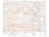
1953 Map of McIntosh
USGS Topo · Published 1973About this map
The Standing Rock Indian Reservation and Cheyenne River Indian Reservation dominate this mid-century landscape, where the Missouri River forms the sprawling Lake Oahe. The map documents a critical period of transition for the region, capturing the impact of the newly created reservoir on local geography. Rail travel remains central to the infrastructure, with the Chicago Milwaukee St Paul and Pacific line connecting northern settlements like McIntosh and Watauga to the grain and cattle hubs of Mobridge and Pollock.
Find a feature on this map
90 named features on this map. Tap any name to fly to it.
Don’t see what you’re looking for? This feature index may not catch every label — zoom into the map to look around manually.
Map Details
Editions of this 1953 McIntosh Map
3 editions found

Other maps of this area

1951 · Ridgeview NW
USGS Topo · 1:24,000

1951 · Redelm NE
USGS Topo · 1:24,000

1951 · Virginia
USGS Topo · 1:24,000

1951 · Dupree NE
USGS Topo · 1:24,000

1951 · Ridgeview NE
USGS Topo · 1:24,000

1951 · Redelm NW
USGS Topo · 1:24,000

1951 · Faith NE
USGS Topo · 1:24,000

1951 · Thunder Butte
USGS Topo · 1:24,000

1951 · La Plant
USGS Topo · 1:24,000

1951 · Promise
USGS Topo · 1:24,000