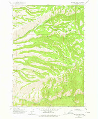
1963 Map of McKinzie Creek
USGS Topo · Published 1978About this map
Nez Perce National Forest dominates this vertical Idaho landscape, where high ridges and deep watercourses define the early 1960s terrain. The area is marked by a network of seasonal routes including Dairy Mountain Road and Wild Horse Road, alongside several Jeep Trails that suggest a wilderness managed for both conservation and grazing. Evidence of land use is found at the Wild Horse Corrals and the Guard Station near Little Van Buren Creek.
Find a feature on this map
34 named features on this map. Tap any name to fly to it.
Don’t see what you’re looking for? This feature index may not catch every label — zoom into the map to look around manually.
Map Details
Editions of this 1963 McKinzie Creek Map
2 editions found
Other maps of this area

1955 · Grangeville
USGS Topo · 1:250,000

1959 · Grangeville
USGS Topo · 1:250,000

1963 · John Day Mtn
USGS Topo · 1:24,000

1963 · Lucile
USGS Topo · 1:24,000

1963 · McKinzie Creek
USGS Topo · 1:24,000

1963 · Goodwin Meadows
USGS Topo · 1:24,000

1963 · White Bird Hill
USGS Topo · 1:24,000

1963 · Slate Creek
USGS Topo · 1:24,000
1963 · Dairy Mountain
USGS Topo · 1:24,000

1963 · White Bird
USGS Topo · 1:24,000