
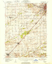
1951 Map of McLean
USGS Topo · Published 1951About this map
Bloomington anchors the northeastern corner of this mid-century survey, showing the city's early development around the Illinois Central and New York Central rail corridors. The landscape is defined by its deep agricultural roots and a sophisticated network of country schools and churches that served the outlying townships. Prominent rural hubs like McLean and Atlanta appear along the Gulf Mobile and Ohio line, which cuts diagonally across the prairie. Local history is preserved through numerous family-named landmarks and resting places, such as Mount Hope Cem and Brooks Grove Cem. One notable landmark is the Radio Sta WJBC near the city, while the southern reaches of the map near Wapella and Waynesville trace the winding path of Kickapoo Creek.
Find a feature on this map
61 named features on this map. Tap any name to fly to it.
Don’t see what you’re looking for? This feature index may not catch every label — zoom into the map to look around manually.
Map Details
Editions of this 1951 McLean Map
2 editions found
Other maps of this area

1911 · Lincoln
USGS Topo · 1:62,500

1913 · Lincoln
USGS Topo · 1:62,500

1926 · Normal
USGS Topo · 1:62,500

1927 · Danvers
USGS Topo · 1:62,500

1928 · Mackinaw
USGS Topo · 1:62,500

1930 · Danvers
USGS Topo · 1:62,500

1930 · Normal
USGS Topo · 1:62,500

1932 · Mackinaw
USGS Topo · 1:62,500

1949 · Mc Lean
USGS Topo · 1:62,500

1951 · Minier
USGS Topo · 1:62,500