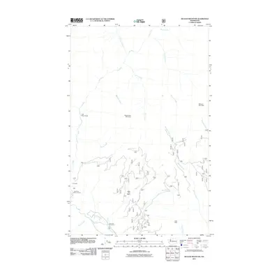
2011 Map of McLeod Mountain
USGS Topo · Published 2011About this map
Lost River drainage and the steep mountainous terrain of Okanogan County define this 2011 survey. The landscape is marked by dramatic elevation changes, from the depths of Lost River Gorge to the high peaks of McLeod Mountain and Setting Sun Mountain. Human activity is concentrated along the river corridors and forest access routes, including Nat For Devrd 100. The small settlement of Yellowjacket and the Lost River Resort Airport sit near the confluence of Yellowjacket Creek, providing a rare point of aviation access in this high-altitude environment. Recreational use of the national forest is evident at the Gate Creek Campground near where Gate Creek enters the Methow River. The map also captures numerous drainage systems such as Hurricane Creek and Whiteface Creek that carve through the complex geography of Black Pine Basin.
Find a feature on this map
26 named features on this map. Tap any name to fly to it.
Don’t see what you’re looking for? This feature index may not catch every label — zoom into the map to look around manually.
Map Details
Editions of this 2011 McLeod Mountain Map
This is the sole edition of this map. No revisions or reprints were ever made.
Other maps of this area

1920 · Slate Pass
USGS Topo · 1:125,000

1955 · Concrete
USGS Topo · 1:250,000

1958 · Concrete
USGS Topo · 1:250,000

1962 · Concrete
USGS Topo · 1:250,000

1962 · Mazama
USGS Topo · 1:62,500

1963 · Silver Star Mtn.
USGS Topo · 1:24,000
1963 · Robinson Mtn.
USGS Topo · 1:24,000

1969 · Lost Peak
USGS Topo · 1:24,000

1969 · Billy Goat Mtn
USGS Topo · 1:24,000
1969 · Mount Lago
USGS Topo · 1:24,000