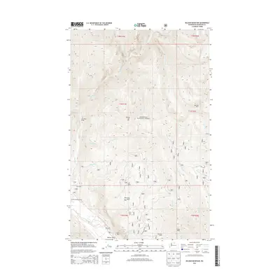
2014 Map of McLeod Mountain
USGS Topo · Published 2014About this map
Okanogan National Forest dominates this section of Washington's North Cascades, defined by a dramatic drainage system where the Lost River and its tributaries carve through high-elevation terrain. The map traces the confluence of the Lost River and Methow River near the Methow Valley, a crucial junction for the region's geography. Notable landmarks such as the Lost River Gorge and the imposing Goat Wall overlook the river valley, while summits like McLeod Mtn and Goat Peak anchor the surrounding ridges. Local recreation and aviation are represented by the Lost River Resort Airport, located near the intersection of various forest roads. The presence of Spokane Gulch and Black Pine Basin suggests the diverse landforms and micro-environments found within this protected wilderness, as documented in 2014.
Find a feature on this map
47 named features on this map. Tap any name to fly to it.
Don’t see what you’re looking for? This feature index may not catch every label — zoom into the map to look around manually.
Map Details
Editions of this 2014 McLeod Mountain Map
This is the sole edition of this map. No revisions or reprints were ever made.
Other maps of this area

1920 · Slate Pass
USGS Topo · 1:125,000

1955 · Concrete
USGS Topo · 1:250,000

1958 · Concrete
USGS Topo · 1:250,000

1962 · Concrete
USGS Topo · 1:250,000

1962 · Mazama
USGS Topo · 1:62,500

1963 · Silver Star Mtn.
USGS Topo · 1:24,000
1963 · Robinson Mtn.
USGS Topo · 1:24,000

1969 · Lost Peak
USGS Topo · 1:24,000

1969 · Billy Goat Mtn
USGS Topo · 1:24,000
1969 · Mount Lago
USGS Topo · 1:24,000