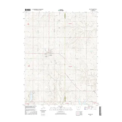
2015 Map of McLouth
USGS Topo · Published 2015About this map
McLouth serves as the central hub for this northeast Kansas landscape, where the grid of Jefferson County meets the Leavenworth County line. The settlement is defined by its residential streets like E Agnes St and Kimberlin St, while the surrounding rural township is marked by local aviation and historic burial grounds. For researchers of family history, Fowler Cem, McLouth Cem, and Wildhorse Cem are significant landmarks. The terrain is deeply carved by a network of waterways including Prairie Cr, Ninemile Cr, and Slough Cr, which drain toward notable bodies of water such as Lake Dabanawa and the State Lake. Aviation activity is represented by both D'Field Airport and the distinctively named Threshing Bee Airport, reflecting the region's blend of modern transport and agricultural tradition.
Find a feature on this map
73 named features on this map. Tap any name to fly to it.
Don’t see what you’re looking for? This feature index may not catch every label — zoom into the map to look around manually.
Map Details
Editions of this 2015 McLouth Map
This is the sole edition of this map. No revisions or reprints were ever made.
Other maps of this area

1886 · Oskaloosa
USGS Topo · 1:125,000

1888 · Oskaloosa
USGS Topo · 1:125,000

1894 · Oskaloosa
USGS Topo · 1:125,000

1948 · Jarbalo
USGS Topo · 1:24,000

1949 · Williamstown
USGS Topo · 1:24,000

1950 · Kansas City
USGS Topo · 1:250,000

1950 · Easton
USGS Topo · 1:24,000

1950 · Williamstown
USGS Topo · 1:24,000
1950 · Jarbalo
USGS Topo · 1:24,000
1950 · Midland
USGS Topo · 1:24,000